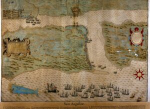


1586 Drake's Raid on St. Augustine
Plano del pueblo, fuerte y caño de San Agustín de la Florida y del pueblo y caño de San Sebastián.
1586 map by Baptista Boazio showing St. Augustine during Sir Francis Drake’s raid.

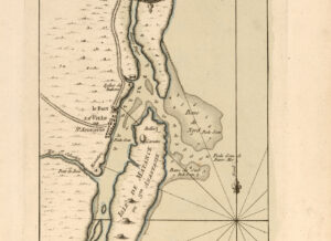
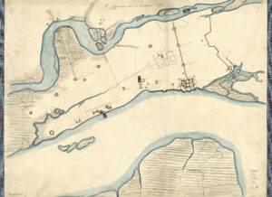
Mestas Town Map
Plano del pueblo, fuerte y caño de San Agustín de la Florida y del pueblo y caño de San Sebastián.
Map of St. Augustine, attributed to Hernando de Mestas, circa 1576.

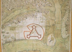
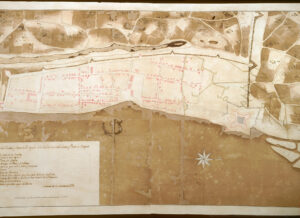
1737 Arredondo Map
Plan de la ciudad de San Agustín de la Florida y sus contornos, situada en la altura septentrional de 29 grados y 50 minutos.
1737 Antonio de Arredondo map of St. Augustine.

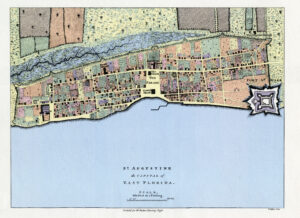
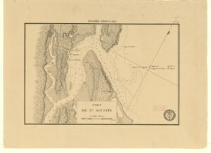
1783 map of the city and port of St. Augustine
Plano de la ciudad y puerto de San Agustin de la Florida.
1783 map of the city and port of St. Augustine by Tomas Lopez de Vargas Machuca.

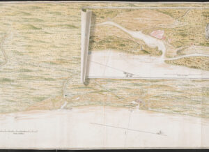
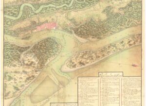
1743, A Survey of the Coast from Fort William near St. Iuans River to Mosquito River
A Survey of the Coast from Fort William near St. Iuans River to Mosquito River.
1743 map by Justly Watson showing north east Florida coast with an inset of St. Augustine.

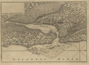
1762 Jefferys Map
Plan of the town and harbour of St. Augustine.
Thomas Jefferys 1762 map of the town and harbor of St. Augustine

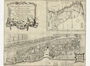
1763 Castello Map
Plano del Presidio de Sn. Agustín de la Florida y sus contornos : situado en el continente de la América del Norte, en los 30g., – min, de latd., el qual con sus dependencias se entregó a S.M.B. en 21 de Julio de 1763 por el artículo 18 de la Paz de Fontainebleau.
1763 Pablo Castello map of St. Augustine and the surrounding areas.

SCETCH of the CITY and Environs of ST. AUGUSTINE
SCETCH of the CITY and Environs of ST. AUGUSTINE.
1763 William Basier map, sketch of the city and environs of St. Augustine.

1764 Bellin Map
Plan du port de St. Augustin dans la Floride.
Jacques Nicolas Bellin map of the port of St. Augustine, ca. 1764.

1764 Jefferys Map- St. Augustine the Capital of East Florida
1764 Thomas Jefferys map, St. Augustine the Capital of East Florida.

1764 Puente Map of St. Augustine
Plano De La Real Fuerza Baluartes Y Linea De La Plaza De San Agustin De Florida.
1764 Juan Joseph Elixio de la Puente map of St. Augustine.

A new & accurate plan, of the town of St. Augustine
1764 John de Solis map A new & accurate plan, of the town of St. Augustine.

A Plan of St. Augustine Town and its Environs in East Florida
1777 J. Parrell map A Plan of St. Augustine Town and its Environs in East Florida.

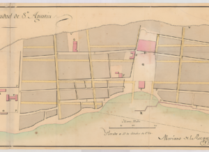
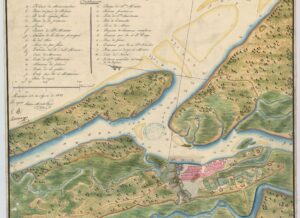
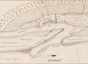
1779 Town Map
Plano de la ciudad y fuerte de San Agustín de la Florida, sus imediaciones y plano de ataques.
1779 map of the city and fort of St. Augustine. Creator unknown.

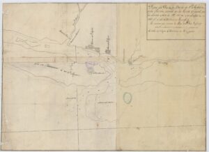
1782 map of St. Augustine
1782 map of St. Augustine and its environs. Creator unknown.

1784 Rocque map of St. Augustine
Plano de la Ciudad de St. Agustin de la Florida.
1784 Mariano de la Rocque map of the city of St. Augustine.

1788 Rocque map of St. Augustine
Plano Particular De La Ciudad De Sn Agustin De La Florida, Con El Detall De Sus Mansanas, Casas Y Solares, Castillo, &C.
1788 Mariano de la Rocque map of St. Augustine.

1791 Rocque map of St. Augustine
Plano general de la Plaza de San Agustin de la Florida y sus inmediaciones : que comprehende [sic] las entradas de sus Barras, rios, Caños, Sienagas, Lineas y Reductos que la circuyen, manifestandose al mismo tiempo (comtemplada la dotación que se computa necesaria) todo lo que se propone para su Defensa.
1791 Mariano de la Rocque map of St. Augustine and surrounding areas.

1797 Berrio Map
Plano del Presidio de San Agustin en la Florida Oriental con la entrada de sus barras y Caños que lo circunda.
1797 Pedro Diaz Berrio map of St. Augustine.

1805 Town Map
The harbour of St. Augustín in East Florida, ca. 1805, creator unknown.

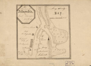
1809 map of the bar and port of St. Augustine
Barra y puerto de San Agustin.
1809 map of the bar and port of St. Augustine, creator unknown.

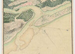
1810 map of port of St. Augustine
Port de Sn. Agustin.
1810 map of the port of St. Augustine, creator unknown.

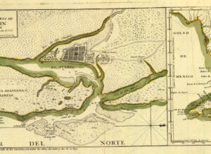
1817 Cortazar map of St. Augustine
Plano de la ciudad de Sn. Agustin en la Florida Oriental con las entradas de sus barras.
1817 Francisco Cortazar map of St. Augustine.

1819(?) Birch map of St. Augustine
Plan of St. Augustine.
1819(?) Lieutenant Birch map of St. Augustine.

18th c. St. Augustine town map
Plano del Puerto y Barra de Sn. Agustín de la Florida : situada en la Florida Oriental por la latitud Norte de 29° 55′ 50″y en longitud de 293° 47′ 00″ del Meridiano de Tenerife.
Map of the Harbor and Bar of San Agustin, Located in East Florida. Anonymous, 18th century.