| Location: | St. Augustine, FL |
|---|---|
| Excavator(s): | Kathleen Deagan; Charles Fairbanks |
| Dates excavated: | 1972 (Fairbanks); 1973 (Deagan) |
Overview
The de la Cruz site (SA 16-23) is located at 20 Spanish Street (Block 16, Lot 23) in St. Augustine, Florida. The house is named after María de la Cruz, who acquired the property during the early eighteenth-century Spanish I Period with her husband Pedro Tomás de Ribera. Two stone houses were constructed on the property sometime during the de la Cruz-Ribera residency. At the start of the British Period (1763-1783), the lot was purchased by Samuel Piles. After 1777, Bartolomé Usina and his family moved onto the lot and built a timber frame home. The Usinas occupied the property throughout the remainder of the British Period and retained ownership of the lot during the Spanish II Period (1783-1821) and into Florida’s Territorial Period (1821-1845) under the United States government.
Most of the site’s documented history has been brought to light through a combination of historical records and archaeological research (Cusick 1993; Deagan 1974, 1983; Harmen 1971; McMurray 1975; Parker 1999). The first excavation of the de la Cruz site was in 1972 following a decision, approved by the city of St. Augustine, to develop the property. Directed by Charles Fairbanks and supervised by Carl McMurray and Bruce Council, the 1972 excavation, completed by a University of Florida field school, focused on defining the lot’s eighteenth-century coquina stone and poured tabby homes. Historic records and maps reveal that the use of coquina and tabby for building residential homes in St. Augustine did not come into widespread use until after 1703 (Arnade 1961: 152; Manucy 1962; McMurray 1975: 10). The decision to utilize coquina and tabby over material such as wood was largely due to the destruction left behind by Governor James Moore’s 1702 siege of St. Augustine. Coquina stone and tabby (a mixed of crushed oyster shell, sand, and lime) provides a more durable and fire-resistant material than wood. In 1973, Kathleen Deagan supervised an excavation under the direction of Charles Fairbanks. Additional architectural features, such as a detached kitchen dating to the eighteenth-century, were documented along with multiple activity areas within the former courtyard and beyond the property’s garden wall. Questions guiding the 1973 project focused on intermarriage and cultural exchange between Spanish men and Native American women who lived in colonial St. Augustine.
Documentary Evidence
The earliest reference of the de la Cruz site is found on the 1762 Jefferys map. The map, which shows two houses and outbuildings, was based “chiefly from original drawings taken from the Spanish in the last war” (Jefferys 1762). The last war referred to by Jefferys was likely Governor James Oglethorpe’s 1740 siege of St. Augustine. Subsequent maps by John de Solis (1763) and Juan Elixio de la Puente (1764) depict two houses in the same location as those illustrated on the Jefferys map. Additionally, the Key list provided on the de la Puente map lists the de la Cruz property as belonging to the heirs of one María de la Cruz.
Questions regarding the identity of the former owner, María de la Cruz, fall along two lines of interpretation. Research by Carl McMurray (1972) and Kathleen Deagan (1974) concluded that the María de la Cruz listed on the de la Pente map was a Native American woman who had married a Spanish soldier named Jospeh Gallardos. However, Susan Parker challenged this interpretation. According to Parker (1989; 1999: 73ftn29), several women by the name María de la Cruz lived in St. Augustine during the eighteenth-century Spanish I Period. Parker’s research concluded that the María de la Cruz listed on the de la Puente map was a different Native American woman who had married a Guale enlisted soldier named Pedro Tomás de Ribera. The current consensus among most scholars is Parker’s interpretation. The following documentary evidence focuses on the de la Cruz-Ribera family (see McMurray (1972) and Deagan (1974) for a background review of the María de la Cruz who married Jospeh Gallardos).
Records indicate both de la Cruz and de Ribera moved to St. Augustine from Tolomato village, located just west of Spanish Street where the de la Cruz site is located. Based on de la Cruz’s village origin, Ganong (1974: 2) suggests that she was likely Guale or Yamasee. Furthermore, Parish records show that de Ribera made sworn statements that he was a native of his Guale (Ibaja) village (Parker 1999: 52). De la Cruz perhaps worked as a midwife while de Ribera, who served as a private in the calvary, earned an annual income of around 150 pesos. Together they had four children, and their lot, which included “2 stone houses,” measured 44 varas (121 ft) by 95 varas (261.25 ft) (Harmen 1971: 37). As a Native American family living within the protected walls of St. Augustine, de Ribera claimed he and his family were parishioners and citizens and were listed as such on the official rolls. According to Parker (1999: 54), this “distinction between full-fledged parishioner and mission Indian meant the difference between independence or dependency, between being a legally full member of the society, a vecino, or being a ward under the jurisdiction of the friars.” In 1746, de Ribera was killed “by the enemy,” which may have been “marauding Indians” (Ganong 1974). The de la Cruz children married into Spanish families and took ownership of the property following their mother’s passing near the end of the Spanish I Period. When the British took over Florida in 1763, the de la Cruz children departed.
In 1764, the de la Cruz property was appraised at 600 pesos. Working on behalf of the de la Cruz children, Juan Elixio de la Puente sold the property to Samuel Piles. No information is provided on Piles beyond the transaction, and it is unclear what took place on the lot during the early years of the British Period (Ellrich 2023: 138). Joyce Harman (1968: 61-62) references a man named Samuel Piles who, in 1762, was charged by Georgia authorities for trading supplies with St. Augustine after prohibitions were put in place by Governor James Wright. While it is uncertain if this is the same Piles who purchased the de la Cruz property, additional records show that the Piles mentioned by Harmen was owed a large debt by St. Augustine residents.
Bartolomé Usina moved onto the property sometime after 1777. A Minorcan, he and his family were refugees who relocated to St. Augustine following ill-treatment at the hands of Dr. Andrew Turnbull in New Smyrna, Florida (Griffin 2017). Although Usina did not obtain a title of ownership for the property, he built a timber frame home on the lot. The Usinas remained in St. Augustine following the return of Spanish rule in 1783. The 1788 de la Rocque map lists the lot as having a “timber-frame and single shingle house, in bad condition, palm thatch room, owned by Bartholome Usina; lot owned by the Crown” (Harman 1971: 38). Neither the de la Roque map of 1788 or the Berrio map of 1791 show the “2 stone houses” originally belonging to the de la Cruz-Ribera family, so it may be assumed that the houses were no longer standing (Deagan 1974: 46). Usina and his wife, María Luke, had three children, and Usina worked as a farmer on land north of St. Augustine. In 1790, Usina pledged to purchase the property from the Spanish government. This pledge, however, fell through in 1792 when “Thos. Travers” purchased the lot during a public sale. While not clear, Thos. Travers was perhaps Dr. Thomas Travers. A surgeon in the British Army, Dr. Travers remained behind at the end of the British period and continued his practice as a medical doctor (Ellrich 2023: 138-139). Nothing beyond the sale is mentioned about Travers.
A year after Usina’s passing in 1802, the Spanish government remitted all quitrents the family owed in virtue of the Royal cédula of June 17, 1801. This act provided the Usinas legal title of the property. An 1803 account indicates that the lot size during the Usinas ownership measured 39 varas (107.25 ft) by 79 varas (217.25 ft) and was bounded by properties owned by Miguel García, Miguel Costa, and Antonio the Greek (Harman 1971: 39). The 1834 Clements survey lists María Usina as the owner of the property. One of the Usinas children was named María, and it is unclear if the María listed as the owner was Usina’s wife or daughter. Based on a 1793 census, Usina’s wife would have been 81 years of age and his daughter 49 years of age during the 1834 survey.
Excavation History, Procedure, and Methods
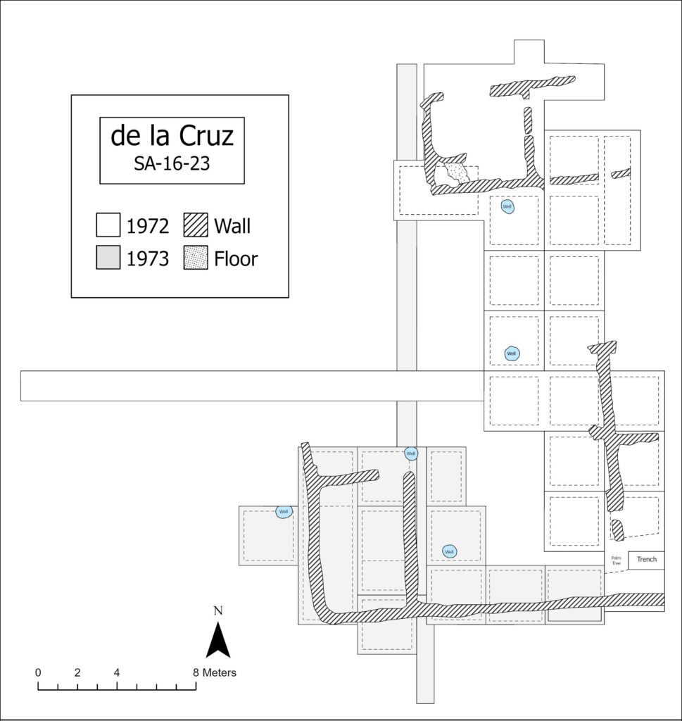
Charles Fairbanks directed the first excavation of the de la Cruz site in 1972. The excavation, part of a University of Florida field school, was originally intended to explore the Minorcan presence on the lot but eventually turned to the eighteenth-century Spanish I Period following the discovery of tabby foundations related to the de la Cruz-Ribera residence (McMurray 1975). The field notebook(s) and feature records for the 1972 excavation have been lost. However, maps and other associated records for the field season are available.
Carl McMurray and Bruce Council supervised the 1972 field school. An intensive surface collection of the property aided in the placement of the site grid. Vertical control was maintained using a transit—and a temporary benchmark—established on the southeast corner of the “Old City Laundry Building” north of the site (McMurray 1975: 15). Two manhole covers on Spanish Street were used to record the above mean sea level (MSL) for units and features. All excavated soil was screened using 1/4 hardware cloth, and a total of 44 units were excavated at varying sizes and were designated by their southwest corner. Major trench lines, segmented into discrete units, were excavated first to uncover and define the tabby foundations discovered. Additional units, mostly 10 x 10 feet, included two-foot-wide baulks between the 10 x 10 units. The first units were excavated in arbitrary 6-inch levels with the rest proceeding by natural strata.
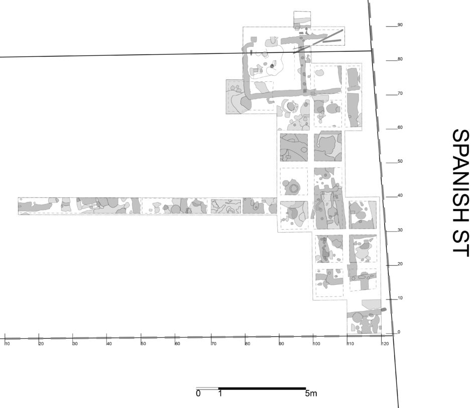
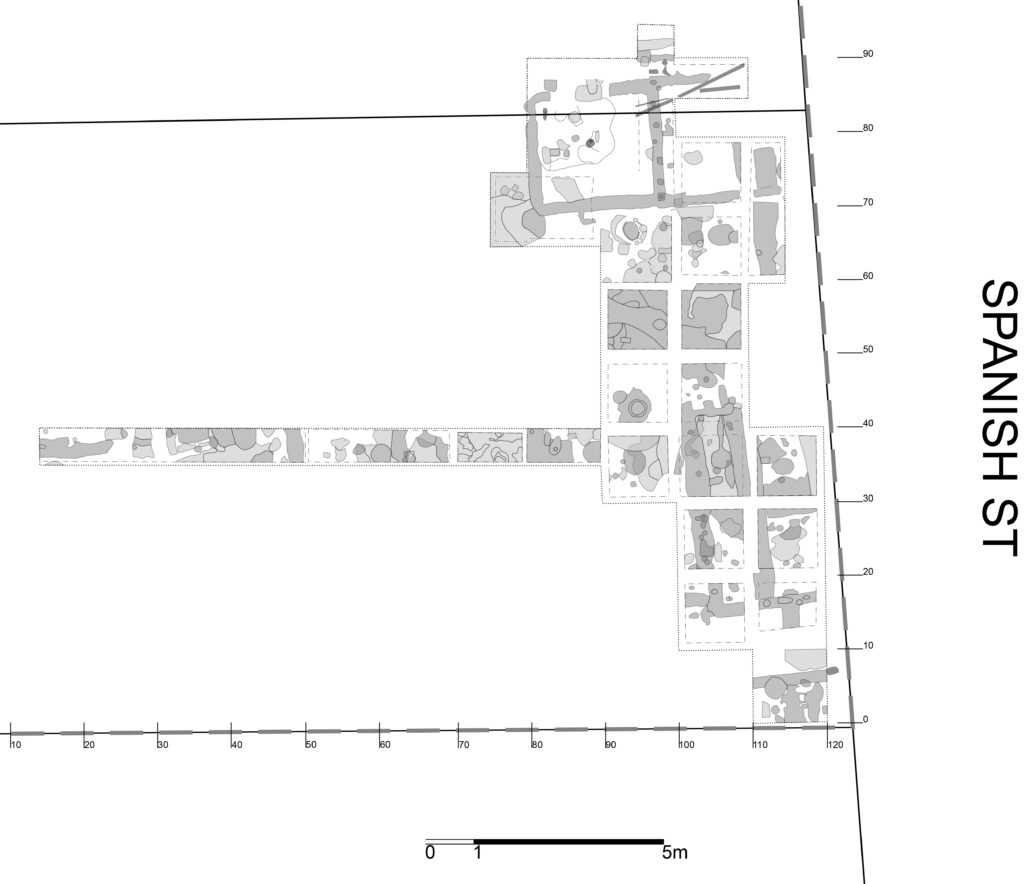
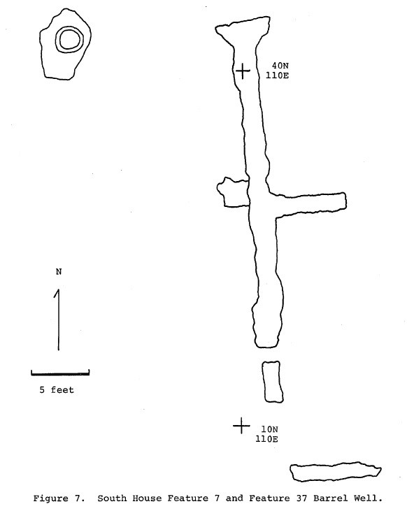
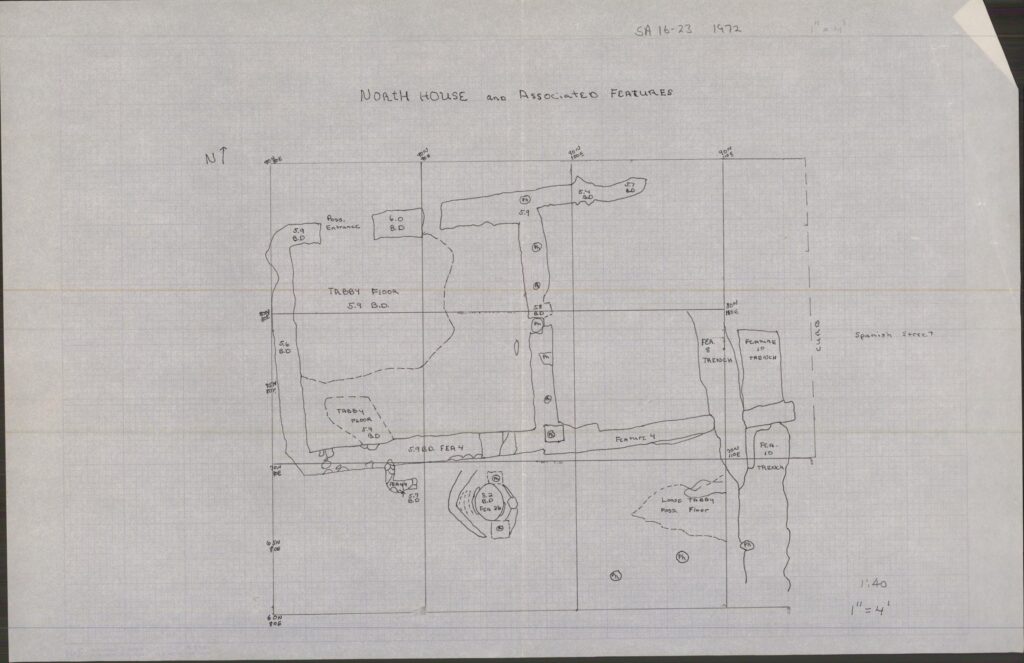
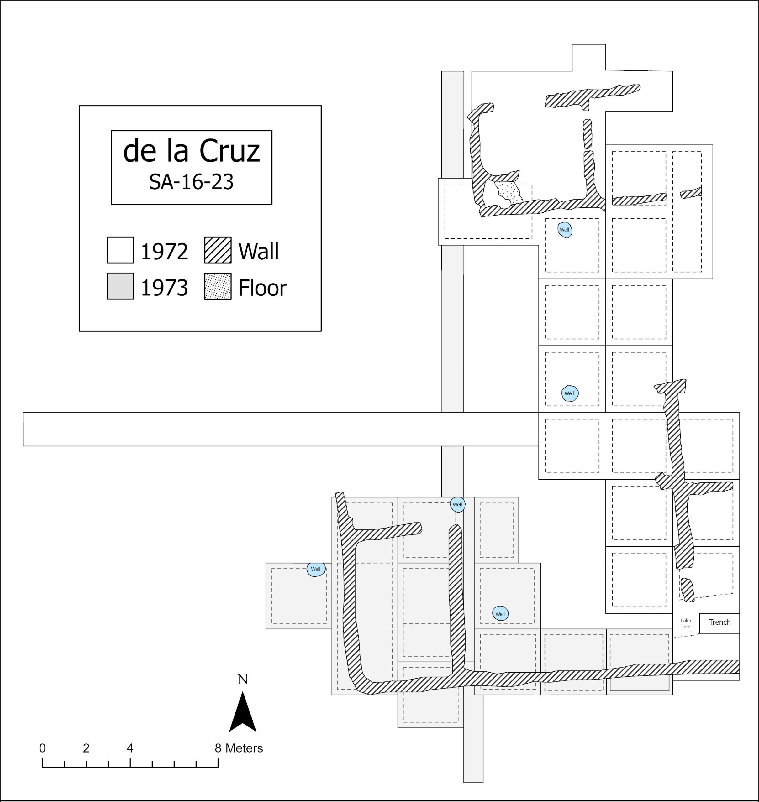
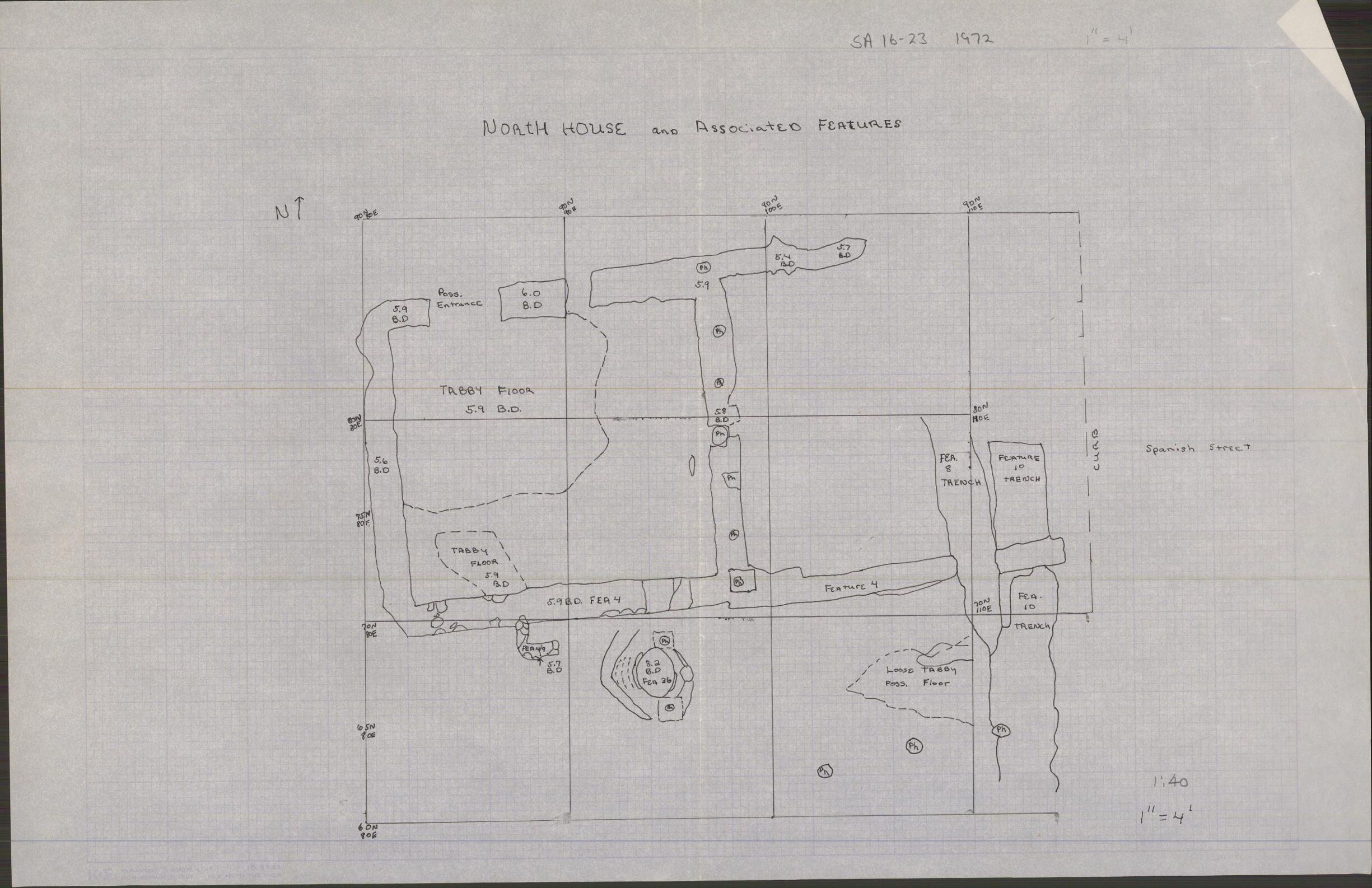
McMurray (1975: 17) reported that the most significant features uncovered were numbers 4 and 7. Both were interpreted as the foundations of the “2 stone houses” listed on the 1764 de la Puente map. The two houses, labeled the North House and the South House, became focal points of the excavation. Exposed rectangular footings of the North House (Feature 72-4) varied in width from 18 to 60 centimeters, and the size of the house measured approximately 5.1 meters (north-south) by 10.3 meters (east-west). Furthermore, a central partition wall of poured tabby within the North House provided evidence of a two-room living space. Both rooms measured roughly 4.5 x 4.5 meters. The recovery of squared coquina rubble courses indicated that the North House’s outer walls had been made of coquina, and based on the thickness of the house’s poured tabby foundations, it was at least one and a half stories high (McMurray 1975: 18). A series of postholes along the south side of the North House confirmed the presence of an open loggia that measured approximately 2.4 meters (north-south) by 5.4 meters (east-west). Based on the architectural evidence and Carl Manucy’s (1962) study of colonial St. Augustine architecture, McMurray (1975) concluded that the North House was a St. Augustine Plan (defined as a one and a half or two-story home distinct from the “Common Plan” due to the addition of storied levels).
The South House foundations (Feature 72-7) were approximately 7.5 meters south of the North House. The dimensions of its footings were “almost exactly the same width and thickness as those of the North House” (McMurray 1975: 19). However, the South House was slightly longer with a north-south measurement of roughly 11.8 meters. Modern sewer line disturbance in the area prevented a full account of the South House’s width. The South House’s interior space included an off-centered partition wall, offering a 3.6 meter long north room and a 6.4 meter long south room. Similar to the North House, coquina rubble courses provided evidence that the exterior walls had been made of coquina. A loggia was not uncovered since its hypothesized location on the east side of the home was located beneath the nearby street. McMurray (1975: 20) reported that the South House was probably a two-story St. Augustine Plan or perhaps even a Wing Plan based on tentative evidence of a possible third room on the west side.
Through a combination of archaeological evidence and historic records, McMurray (1975: 23) proposed that the construction of the two houses probably took place sometime between 1713 and 1739. Additionally, evidence at the South House indicated that a distinctive post and wall trench for a wooden house cut through the original tabby foundation. Deagan (1974: 46) suggested that this evidence was perhaps the wooden house Usina had built on the property in the late 1770s. Overall, the 1972 field season resulted in the excavation of 56 features. Two of these features were barrel wells. One of the barrel wells (Feature 72-37) had a wooden hoop about 1 inch thick and approximately 28 inches in diameter. The well extended to a depth of 2.49 meters below the site datum and required the installation of well points and a pump to fully excavate due to the site’s high water table.
In 1973, Kathleen Deagan supervised an excavation with Fairbanks as the principal investigator. The field crew included graduate students Stephen Cumbaa, Nicholas Honerkamp, Carlos Martinez, John Otto, and Russell Lewis. The goal of the excavation was to expose as much of the eighteenth-century lot area as possible and define activity areas, particularly those believed to have been associated with women (Deagan 1974: 50). Research questions guiding the excavation were explicitly processual and focused on understanding patterns of cultural exchange through the intermarriage of Spanish men and Native American women (Deagan 1973, 1974, 1983). The 1972 site grid was reestablished and extended, and excavated soil was initially dry screened using 1/4 inch hardware cloth but shifted entirely to water screening after the second week. Furthermore, Zone 1 soil (identified as pre-eighteenth-century) was generally stripped off and discarded (Deagan 1974: 49). A total of 11 units were excavated. Most of the units measured 3 x 3 meters, and their coordinates were based off of the southwest corner. Soil samples, taken at intervals and from identified trash pits, were collected for pollen analysis. Additionally, soil samples from certain features were collected for flotation in order to recover small faunal remains. Due to the site’s high water table, well points and a pump were used in select areas. Activity areas excavated included a detached kitchen, an outbuilding to the north of the kitchen, the courtyard, several areas outside of the garden wall, and three wells (Deagan 1974).
The detached kitchen measured approximately 7.5 meters (north-south) and 5.0 meters (east-west). Underlying Zone 2 of the kitchen area, four large trash pits, four fire pits, and a series of postholes were discovered. Three of the fire pits (Features 73-22, 73-24, and 73-31) were located within the walls of the kitchen and included the recovery of charred corn cobs, burnt ceramic sherds, oyster shell, and animal bones. No oven, or other feature that would indicate an oven, was located. Excavations along the northern half of the kitchen exposed a pre-1763 tabby floor (Feature 73-26). One discovery below this sealed floor was a creamware sherd. Produced in small quantities during the 1750s before gaining popularity in the 1760s and 1770s (Noël Hume 1969: 123-126), the recovery of a creamware sherd below the pre-1763 sealed tabby floor led Deagan (1975: 24) to suggest that early versions of creamware perhaps entered St. Augustine during the eighteenth-century Spanish I Period. Other artifacts recovered within the kitchen included sewing equipment such as straight pins and thimbles, suggesting that the kitchen building was also used as a laundry and/or women’s work area.
Partially excavated in two units, the outbuilding located to the north of the kitchen contained evidence of a wall trench (Feature 73-29) that aligned with and extended from the kitchen’s west wall. Artifacts recovered in this trench provided a construction date no earlier than 1720. Deagan (1974: 58) remarked that much of the outbuilding area was severely disturbed by the construction of a nineteenth-century coquina well that contained transfer-printed pearlware.
Excavation units in the courtyard area provided the richest evidence of past activity. Large trash pits were the most common features, particularly those around an eighteenth-century barrel well. One clay-lined circular pit (Feature 73-34) appeared to be a latrine pit based on the soil sample results which contained high levels of phosphates, nitrates, and calcium. Several large scatters of clay with a high concentration of kaolin were discovered within the courtyard as well. Clay sourcing analysis showed that when fired, the texture of the clay scatter recovered in the courtyard was very similar to a clay deposit located approximately 15 miles south of the de la Cruz site on the intercoastal waterway (Deagan 1974: 60-61). The presence of this clay, along with worked flint (n=32, or 84% of all worked flint recovered during the excavations), led Deagan (1974) to conclude that craft activities had been carried out within the courtyard area.
Excavations outside of the garden wall included areas south of the wall, west of the wall—behind the kitchen—and exploratory trenches. The south wall area included quantities of nineteenth-and twentieth-century debris, several large, nineteenth-century trash pits, and a single eighteenth-century feature that dated no earlier than 1720. Deagan (1974: 61) further remarked that the location of the eighteenth-century feature fell within the adjacent lot (SA 16-22) occupied by Don Ruiz del Canzo. A rich eighteenth-century midden was exposed in the excavated section west of the garden wall. The midden, approximately 0.75 meters behind the kitchen, contained dense concentrations of bone, shell, and sherds. Several eighteenth-century features were documented in the exploratory trench north of the garden wall. One of the features (73-32) in the north trench resembled the proposed latrine pit (Feature 73-34) documented in the courtyard area. The only evidence of eighteenth-century activity in the two exploratory trenches south of the garden was an exposed portion of Canzo’s house wall. With little evidence of eighteenth-century activity on the portion of the lot behind and between the two de la Cruz houses, Deagan (1974: 63) concluded that the area during the eighteenth-century Spanish I Period was probably a garden and orchard area such as those designated on the 1764 Puente map for other house lots.
Two eighteenth-century barrel wells were discovered in the 1973 excavation. One, found in the courtyard area between the kitchen and the south house, was surrounded by a well pit that measured 1.35 meters in diameter at its widest point. The depth of the courtyard well was 1.69 meters from the colonial ground surface and contained ceramic sherds (n=128), two brass gun sideplates, a whole preserved orange, plant remains, and a few indiscernible pieces of leather (Deagan 1974: 63-65). The second barrel well was located beyond the kitchen and garden wall on the west side of the property. Unlike the courtyard well, it was encased in coquina stone. Time constraints did not allow the well to be fully excavated but, based on the portion exposed and the dimensions of the courtyard well, Deagan (1974: 68) proposed that it would have extended about 1.54 meters below the colonial ground surface. Artifacts recovered from the second well included ceramic sherds (n=321), glass, a large quantity of animal bone, a substantial number of wrought nails and spikes, and various musket parts.
Summary of Research and Analysis
The first site in the city to be excavated with an explicitly processual problem orientation (Deagan 1983: 100), the de la Cruz site has contributed much to colonial St. Augustine’s multicultural history. The 1972 and 1973 excavations produced a total of 56 discrete proveniences dating to the eighteenth-century Spanish I Period and over 300 others post-dating 1763. Poured tabby footings excavated and defined between the two field seasons resulted in the identification of two houses built by the de la Cruz-Ribera family during the eighteenth-century Spanish I Period. Additional finds associated with the eighteenth-century Spanish I Period include a well garden area that had enclosed the south side of the lot, an oyster-shell packed trench footing for a third structure, 3 barrel wells, and 30 discrete trash pits (Deagan 1983: 106).
Debate surrounds the identification of the María de la Cruz who owned the property during the eighteenth-century Spanish I Period (see Parker 1989; 1999: 73ftn29). Both María de la Cruzes identified in the literature were Native American women (Guale or Yamasee) who had married soldiers enlisted under the Spanish Crown. The current consensus among most scholars is that the María de la Cruz who owned the property is the one who had married Pedro Tomás de Ribera. The lot during the British Period passed through several hands and included the Usina family who arrived sometime after 1777. Minorcan refugees from the ill-fated New Smyrna colony south of St. Augustine, the Usinas built a timber frame home on the property. During the Usina residency, the neighborhood surrounding the lot transitioned into what some scholars refer to as St. Augustine’s Minorcan Quarter (Cusick 1995; Griffin 2017; Johnson 1988). Records indicate that the Usinas retained ownership of the lot leading into Florida’s Territorial Period (Harman 1971).
Zooarchaeological analyses have been conducted on food remains recovered from both the 1972 and 1973 field seasons. Cumbaa’s (1975) analysis of three eighteenth-century Spanish I Period house lots (SA 13-5, SA 16-23, and SA 34-2) concluded that the de la Cruz-Ribera family had incorporated less domestic meat than the two non-Native American households analyzed. The presence of wild birds and aquatic reptiles associated with the de la Cruz-Ribera family stood out as well, and the relatively high presence of swine (Sus scrofa) indicates that the family perhaps raised pigs on the property (Reitz and Cumbaa 1983: 181). Cusick’s (1993: 203) study of Spanish II Period house lots reported that there are no faunal remains related to the Usina occupation.
Gifford Waters and Charles Cobb
Florida Museum of Natural History
University of Florida, Gainesville, FL
July 2025
Records note:
The field notebooks for the 1972 and 1973 field seasons are missing. The following methods and protocols provided below was obtained from Carl McMurray’s 1975 master’s thesis (which focused on the 1972 excavations) and Kathleen Deagan’s 1974 dissertation (which focused on the 1973 excavations). All the 1972 field season feature types listed as “Unidentified” are because (1) McMurray’s thesis does not mention them and (2) accessible records do not identify/describe them.
Feature numbers were duplicated between the 1972 and 1973 field seasons. Therefore, to distinguish the two field seasons, features contexts were provided a hyphenated clarifier (e.g., F6-72 for the 1972 field season and F6-73 for the 1973 field season).
Field Methods and Protocols:
1972: McMurray (1975: 15-16): Units were 10 x 10 feet, and baulks two feet wide were left between squares, which means that actual digging area per square was only 8 feet by 8 feet. Squares were designated by the number on their southwest corner stakes. The first two squares were excavated by arbitrary 6-inch levels; all other squares were dug by natural strata. Material was sifted through ¼ screen mesh.
• The imperial system.
• Screened using ¼ mesh.
• Unit coordinates are based on the southwest corner.
• The first two squares were excavated by arbitrary 6-inch levels; all other squares were dug by natural strata.
1973: Deagan (1974: 48) dissertation: The excavation controls employed during the 1972 season were essentially similar to those used (and described below) in the 1973 excavation.
• The metric system (not imperial) was used.
• Started off dry screened using ¼ mesh. By the second week of excavation, the screening process converted entirely to water screening (Deagan 1974: 52).
• Unit coordinates are based on the southwest corner.
• Deagan (1974: 51): Soil samples were taken at intervals, and from trash pits for soil and possibly pollen analysis; and flotation samples were taken from certain features in order to recover plant and very small faunal remains.
• Deagan (1974: 53): The 1973 excavations included the areas of the “kitchen,” the courtyard, the outbuilding to the north of the kitchen, the midden area outside the garden wall, the exploratory trenches, and the wells.
Datum:
1972 Field Season: (McMurray 1975: 15-16): The Datum Plane was 4.2 feet above present ground surface; all vertical measurements were taken down from this plane. In order that general elevation of the site relative to mean sea level might be known, elevations of two manhole sewer covers were run in. These covers were directly adjacent to the site in Spanish Street. From the transit station to the center of the cover located just south of the south wall of the Old City Laundry building, the angle is N39° 33’E at a distance of 111 .0 feet. Elevation 4.20 feet Below Datum; MSL +7.196 feet. From the station to the center of the cover south of the first, the angle is N98° 9’E at a distance of 85.0 feet. Elevation 3.85 feet Below Datum; MSL +7.541 feet.
1973 Field Season: Deagan (1974: 50): An arbitrary datum was established before excavation began, and all levels, features, zones, etc. in the site were measured down from this datum.
• Note: the grid coordinate numbering system between the two field seasons is different.
Unit Measurements: For the 1972 field season, measurements and unit sizes were conducted using the Imperial system. For the 1973 field season, measurements were conducted using the metric system.
• 1972: 10 x 10 feet, 10 x 5 feet
• 1973: 3 x 3 meter, 6 x 3 meter
| Feature | Feature Type | Unit Corner |
| F1-72 | Trench, builder’s | 40N 100E, 20N 100E |
| F2-72 | Unidentified | 20N 100E |
| F2-73 | Pit | 209N 197E |
| F3-73 | Wall, interior stone | 209N 197E |
| F4-72 | Wall, interior stone | 60N 90E, 70N 100E, 70N 110E, 85N 90E |
| F4-72, FLOOR | Floor, tabby | 75N 90E |
| F4-73 | Pit | 209N 197E |
| F5-72 | Pit | 70N 100E |
| F5-73 | Pit | 209N 197E |
| F6-72 | Pit | 20N 110E |
| F6-73 | Pit | 209N 209E |
| F7-72 | Wall, interior stone | 0N 110E, 10N 110E, 20N 110E, 30N 110E, 40N 110E |
| F8-72 | Trench, unidentified | 60N 110E, 70N 110E |
| F8-73 | Pit | 209N 194E |
| F9-72 | Pit | 20N 100E |
| F9-73 | Pit, trash | 209N 194E |
| F10-72 | Trench, unidentified | 60N 110E, 70N 110E |
| F10-73 | Pit, trash | 209N 194E |
| F11-72 | Trench, builder’s | 10N 100E, 10N 110E |
| F11-73 | Pit, trash | 209N 194E |
| F12-72 | Unidentified | 10N 110E |
| F12-73 | Pit | 212N 182E |
| F13-72 | Pit | 10N 110E |
| F14-72 | Unidentified | 10N 100E |
| F15-72 | Pit, trash | 30N 110E |
| F15-73 | Pit, trash | 209N 185E |
| F16-72 | Pit, trash | 30N 110E |
| F16-73 | Possible wattle footing | 209N 185E |
| F17-72 | Trench, unidentified | 10N 100E |
| F18-72 | Pit, trash | 10N 100E |
| F19-72 | Pit | 60N 100E |
| F19-73 | Pit | 209N 191E |
| F20-72 | Pit | 60N 100E |
| F20-73 | Pit | 209N 191E |
| F21-73 | Trench, unidentified | 210.5N 188E |
| F22-73 | Pit | 210.5N 188E |
| F23-72 | Unidentified | 30N 100E |
| F23-73 | Pit | 210.5N 188E |
| F24-72 | Trench, unidentified | 30N 100E, 40N 100E |
| F25-72 | Unidentified | 30N 100E |
| F25-73 | Pit | 215N 185E |
| F26-72 | Unidentified | 40N 100E |
| F26-73 | Floor, tabby | 215N 188E |
| F27-72 | Pit, trash | 30N 100E |
| F28-72 | Unidentified | 50N 90E |
| F28-72-PIT | Pit | 50N 100E |
| F28-73 | Pit | 215N 185E |
| F29-72 | Pit, barrel well | 30N 90E, 40N 90E |
| F29/37-72 | Barrel well | 30N 90E, 40N 90E |
| F29-73 | Pit | 215N 185E |
| F30-72 | Unidentified | 30N 90E |
| F31-72 | Pit | 50N 100E |
| F31-73a | Pit | 215N 188E |
| F31-73b | Pit | 221N 188E |
| F32-72 | Pit | 40N 100E |
| F32-73 | Pit | 227N 188E |
| F33-72 | Pit | 30N 90E |
| F33-73 | Trench, unidentified | 218N 188E |
| F34-72 | Pit | 50N 90E, 50N 100E |
| F34-73 | Pit | 212N 191E |
| F35-72 | Unidentified | 75N 90E |
| F35-73 | Trench, unidentified | 212N 191E |
| F36-72 | Barrel well | 60N 90E |
| F36-73 | Trench, unidentified | 212N 191E |
| F37-72 | Barrel well | 40N 90E |
| F38-72 | Pit | 35N 70E |
| F38-73 | Pit, trash | 212N 191E |
| F39-72 | Pit | 35N 80E |
| F39-73 | Barrel well | 212N 191E |
| F40-72 | Pit | 50N 90E |
| F40-73 | Pit, barrel well | 212N 191E |
| F41-72 | Posthole | 35N 50E |
| F42-72 | Posthole | 35N 50E |
| F43-72 | Trench, unidentified | 85N 90E |
| F43-73 | Pit | 212N 191E |
| F44-72 | Pit | 50N 90E |
| F45-72 | Unidentified | 35N 60E |
| F46-72 | Trench, unidentified | 35N 60E |
| F50-72 | Pit | 35N 40E |
| F51-72 | Pit | 35N 40E |
| F52-72 | Trench, unidentified | 35N 40E |
| F53-72 | Pit, trash (or barrel well pit) | 65N 75E |
| F54-72 | Trench, unidentified | 35N 20E |
| F55-72 | Unidentified | 35N 20E |
| F57-72 | Trench, unidentified | 35N 15E |
| F58-72 | Unidentified | 0N 110E |
| F59-72 | Unidentified | 0N 110E |
| F60-72 | Unidentified | 0N 110E |
| Unnumbered Feature | Feature Type | Unit Corner |
| FLOOR (92-84-73-111) | Floor, tabby | 215N 188E |
| PH (92-84-72-113) | Posthole | 40N 100E |
| PH (92-84-72-116) | Posthole | 50N 100E |
| PH (92-84-72-120) | Posthole | 40N 100E |
| PH (92-84-72-130) | Posthole | 30N 90E |
| PH (92-84-72-131) | Posthole | 30N 90E |
| PH (92-84-72-132) | Posthole | 40N 100E |
| PH (92-84-72-148) | Posthole | 40N 90E |
| PH (92-84-72-149) | Posthole | 40N 100E |
| PH (92-84-72-152) | Posthole | 60N 90E |
| PH (92-84-72-159) | Posthole | 60N 90E |
| PH (92-84-72-161) | Posthole | 60N 90E |
| PH (92-84-72-162) | Posthole | 60N 90E |
| PH (92-84-72-181) | Posthole | 50N 90E |
| PH (92-84-72-182) | Posthole | 50N 90E |
| PH (92-84-72-227) | Posthole | 70N 100E |
| PH (92-84-72-240) | Posthole | 35N 30E |
| PH (92-84-72-270) | Posthole | 65N 75E |
| PH (92-84-72-296) | Posthole | 40N 90E |
| PH (92-84-72-298) | Posthole | 0N 110E |
| PH (92-84-72-303) | Posthole | 0N 110E |
| PH (92-84-72-311) | Posthole | 75N 80E |
| PH (92-84-72-328) | Posthole | 0N 110E |
| PH (92-84-72-338) | Posthole | 75N 90E |
| PH (92-84-72-47) | Posthole | 20N 110E |
| PH (92-84-72-61) | Posthole | 30N 110E |
| PH (92-84-72-62) | Posthole | 10N 100E |
| PH (92-84-72-69) | Posthole | 30N 110E |
| PH (92-84-72-71) | Posthole | 30N 110E |
| PH (92-84-72-77) | Posthole | 60N 100E |
| PH (92-84-72-82) | Posthole | 30N 100E |
| PH (92-84-72-83) | Posthole | 30N 100E |
| PH (92-84-72-84) | Posthole | 30N 100E |
| PH (92-84-72-89) | Posthole | 60N 100E |
| PH (92-84-73-55) | Posthole | 210.5N 188E |
| PH (92-84-73-69) | Posthole | 221N 188E |
| PH (92-84-73-98) | Posthole | 215N 188E |
| PIT (92-84-72-125) | Pit | 40N 100E |
| PIT (92-84-72-155) | Pit | 60N 90E |
| PIT (92-84-72-156) | Pit | 60N 90E |
| PIT (92-84-72-158) | Pit | 60N 90E |
| PIT (92-84-72-170) | Pit | 60N 90E |
| PIT (92-84-72-171) | Pit | 60N 90E |
| PIT (92-84-72-175) | Pit | 60N 90E |
| PIT (92-84-72-272) | Pit | 35N 30E |
| PIT (92-84-72-275) | Pit | 35N 30E |
| PIT (92-84-72-276) | Pit | 35N 80E |
| PIT (92-84-72-323) | Pit | 75N 80E |
| PIT (92-84-72-325) | Pit | 0N 110E |
| PIT (92-84-72-332) | Pit | 0N 10E |
| PIT (92-84-73-101) | Pit | 215N 188E |
| PIT (92-84-73-73) | Pit | 215N 188E |
| PIT (92-84-73-77) | Pit | 224N 188E |
| PIT (92-84-73-79) | Pit | 227N 188E |
| PIT (92-84-73-91) | Pit | 215N 188E |
| PIT (92-84-73-95) | Pit | 215N 188E |
| PIT/Z4 (92-84-72-197) | Pit | 35N 50E |
| PITB (92-84-73-87) | Pit | 212N 191E |
| PITN (92-84-73-81) | Pit | 215N 188E |
| PITUID (92-84-72-103) | Pit | 40N 100E |
| PITUID (92-84-72-104) | Pit | 30N 100E |
| PITUID (92-84-72-119) | Pit | 30N 90E |
| PITUID (92-84-72-150) | Pit | 40N 90E |
| PITUID (92-84-72-199) | Pit | 85N 90E |
| PITUID (92-84-72-207) | Pit | 50N 90E |
| PITUID (92-84-72-210) | Pit | 35N 50E |
| PITUID (92-84-72-213) | Pit | 35N 60E |
| PITUID (92-84-72-242) | Pit | 35N 80E |
| PITUID (92-84-72-243) | Pit | 35N 80E |
| PITUID (92-84-72-248) | Pit | 35N 30E |
| PITUID (92-84-72-250) | Pit | 35N 80E |
| PITUID (92-84-72-253) | Pit | 35N 80E |
| PITUID (92-84-72-291) | Pit | 75N 90E |
| PITUID (92-84-72-304) | Pit | 85N 80E |
| PITUID (92-84-72-307) | Pit | 0N 110E |
| PITUID (92-84-72-310) | Pit | 75N 80E |
| PITUID (92-84-72-313) | Pit | 0N 110E |
| PITUID (92-84-73-39) | Pit | 209N 185E |
| PITUID (92-84-73-58) | Pit | 210.5N 188E |
| PITUID (92-84-73-61) | Pit | 215N 185E |
| PIT (92-84-72-330) | Pit, oyster | 0N 110E |
| PM (92-84-73-56) | Postmold | 210.5N 188E |
| PPH (92-84-72-173) | Possible posthole | 50N 90E |
| PPH (92-84-72-68) | Possible posthole | 10N 100E |
| PPH (92-84-73-42) | Possible posthole | 209N 185E |
| WELL (92-84-72-331) | Well, coquina | N/A |
In contrast to most archaeology websites, iDigStAug contains all of the primary documents associated with the field investigations. By “primary documents” we mean literally all of the field records, field maps, catalogue forms, analytical forms, and photographic slides. In addition, we include technical reports, M.A. theses, and Ph.D. dissertations summarizing some of the studies conducted on these sites. Although iDigStAug contains a digital inventory of re-analyzed artifacts and related contextual records, the availability of the primary documents allows individuals to reach down into minute detail to examine data or drawings that may be of interest. The files are saved in a PDF/A format, an archival protocol that ensures long-term accessibility.

