| Location: | St. Augustine, FL |
|---|---|
| Excavator(s): | Olga Caballero; Kathleen Deagan; Martha Zierden |
| Dates excavated: | 1976-1977 (Deagan); 1979 (Caballero and Zierden) |
Overview
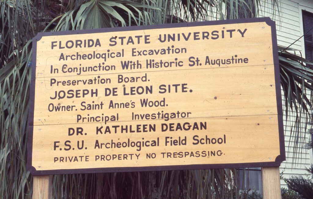
The de León site (SA 26-1) is on a private lot (Block 26, Lot 1) bounded by Bravo Lane to the north, Bridge Street to the south, Charlotte Street on the west, and Marine Street on the east in St. Augustine, Florida. The site is named after Lorenzo Joseph de León, who owned the property during the eighteenth-century-Spanish I period. Archaeological excavations of the site have revealed a domestic history that extends to the mid-to-late sixteenth-century. During the British Period (1763-1783), the lot passed through several hands before Juan José Bousquet gained ownership in 1787. Bousquet and his family lived on the property until the end of the Spanish II Period (1783-1821), and John Drysdale purchased the lot in 1824 and retained ownership until 1858.
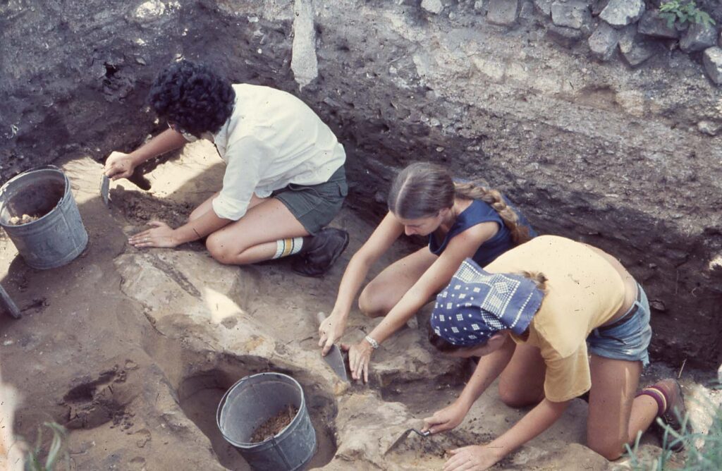
Most of the site’s documented history has been brought to light through a combination of historical records and archaeological research (Barnes 1963a-c; Braley 1977; Caballero and Zierden 1979; Singleton 1977; UFDC 2024c). The first excavation on the de León site was in 1976. Directed by Kathleen Deagan, the 1976 excavation, completed by a Florida State University field school, focused on identifying pre-eighteenth-century components. Subsequent excavations in 1977 and 1979 were conducted with the same goal in mind and included support through the National Endowment for the Humanities (grant No. R032437781425). During the 1979 excavations, it was determined that the area excavated extended onto other eighteenth-century properties owned by Juan Tomas de Castilla and Barbara Garcia. Both de Castilla and Garcia owned property to the south of de León, and sometime after the Spanish II Period the three lots merged. Several barrel wells spanning the late sixteenth and seventeenth centuries have been documented on the site, in addition to a mid-to-late nineteenth-century coquina block well. Structural footings for a colonial era building were also identified along with additional evidence of a possible sixteenth or early seventeenth-century structure that may have incorporated the use of wattle and daub.
Documentary Evidence
The earliest document regarding the de León site is the 1764 de la Puente map which shows five standing structures and their related lots within block “g” (present Block 26). The de León property is listed as #285, and the 1764 map specifies that the property had a standing “stone house” that was owned by Don Lorenzo Joseph de León. De León was born into a prominent and wealthy criollo family in 1698 (Barnes 1963a; UFDC 2024a: 78). A captain of the Mounted Dragoons, de León married three times and had five children (Barnes 1963b). His first wife, Gertrude Florencia, passed away within a year of their marriage in 1721. Four years later he married Petrona Escobar, and after Escobar’s passing in 1754 he married Juana Zamerana. Neighbors of the de Leóns included Juan Tomas de Castilla (property listed as #289) and Dona Barbara Garcia (property listed as #287). De Castilla was a soldier in the Company Morenos libre at Fort Mose and Garcia was a widow who had been married twice (Caballero and Zierden 1979).
In 1764, the de León lot measured 17 varas (46.75 ft) by 39 varas (107.25 ft). That same year, the de Leóns sold “the houses” to Diego (James) Henderson for 700 pesos. The sale, which included SA 26-1 and perhaps a second home on their Aviles Street property (#266-c), was facilitated by Juan Elixio de la Puente (Barnes 1963c). Little is known about Henderson or his connections, and records indicate that he purchased additional properties in town around the same time (Bryant 2017: 42; Escrituras 1784; UFDC 2024b). Within a year Henderson sold “the old house of Don Lorenzo de León” to Jesse Fish for 300 pesos. While there is no mention on the sale of de Castilla’s house and property, Fish also purchased Garcia’s property next door. The Moncrief map of 1765 shows buildings on Garcia and de Castilla’s properties. The structure on Garcia’s was made of tabby and de Castilla’s consisted of both a stone house and a wooden house.
The next reference of SA 26-1 was in 1782 when the British crown granted the lot to John Henely. The following year, a Spanish census reveals that Henley still held ownership of the lot with two other individuals living in his home (UFDC 2024c). The individuals were Juana Robinson and William Strong. Robinson, a widow and native of England, worked as a dressmaker. Strong, a native of New York, was a retired bachelor and farmer who owned “a negress slave” (UFDC 2024c). Henely is also described as a retired bachelor who owned about 300 acres of land on the Nassau River as well as three other lots in St. Augustine. In 1785, Henely sold SA 26-1 to Bernardo Seguí. A prominent and wealthy Minorcan, Seguí worked as a merchant and owned several other lots in town (Cusick 1995; Johnson 1998). Two years later, Seguí transferred his ownership of SA 26-1 to Juan José Bousquet. The chief surgeon of the town’s royal hospital, Bousquet’s salary placed him and his family within the middle strata of Spanish St. Augustine’s bureaucracy (Cusick 1995). The de la Roque map of 1788 lists a tall masonry house in good condition on Bousquet’s lot. Furthermore, the 1788 map lists a timber frame house in bad condition on the former de Castilla property. The timber framed house was owned by Francisco Estacholy who moved to San Vicente Ferrer (St. Johns Bluff) in 1789 (Willis 1985).
The Bousquets occupied SA 26-1 up to the end of the Spanish II Period (1783-1821). In 1824, John Drysdale purchased the lot which eventually merged with the adjacent lots to the south. An 1858 account shows that Lois Drysdale, John Drysdale’s wife, sold to the house to Trinity Church of St. Augustine (Singleton 1977: 15). Trinity Church retained ownership of the property until 1905.
Excavation History, Procedures, and Methods
Kathleen Deagan directed the first archaeological excavation on the de León site in 1976. The excavation, completed as part of a Florida State University field school, focused on locating and defining Spanish I Period (1565-1763) components. Two overarching goals guided the excavation. The first centered on identifying sixteenth and seventeenth-century components since most of the preceding excavations carried out at St. Augustine had uncovered information related to the eighteenth-century (Singleton 1977: ix). The second was comparative as material recovered from the eighteenth-century Spanish I Period could be compared to other contemporaneous house lots previously excavated within the city.
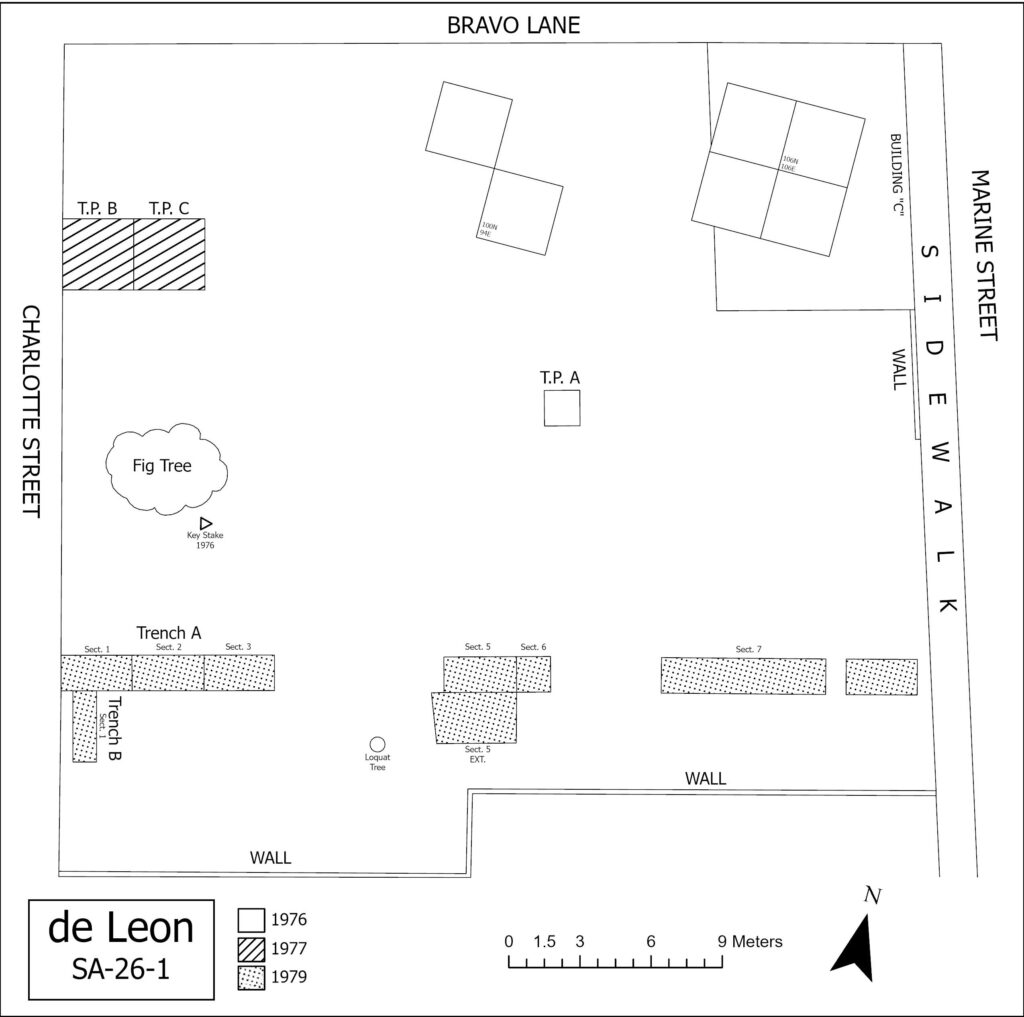
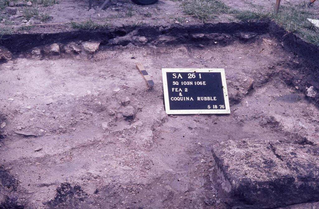
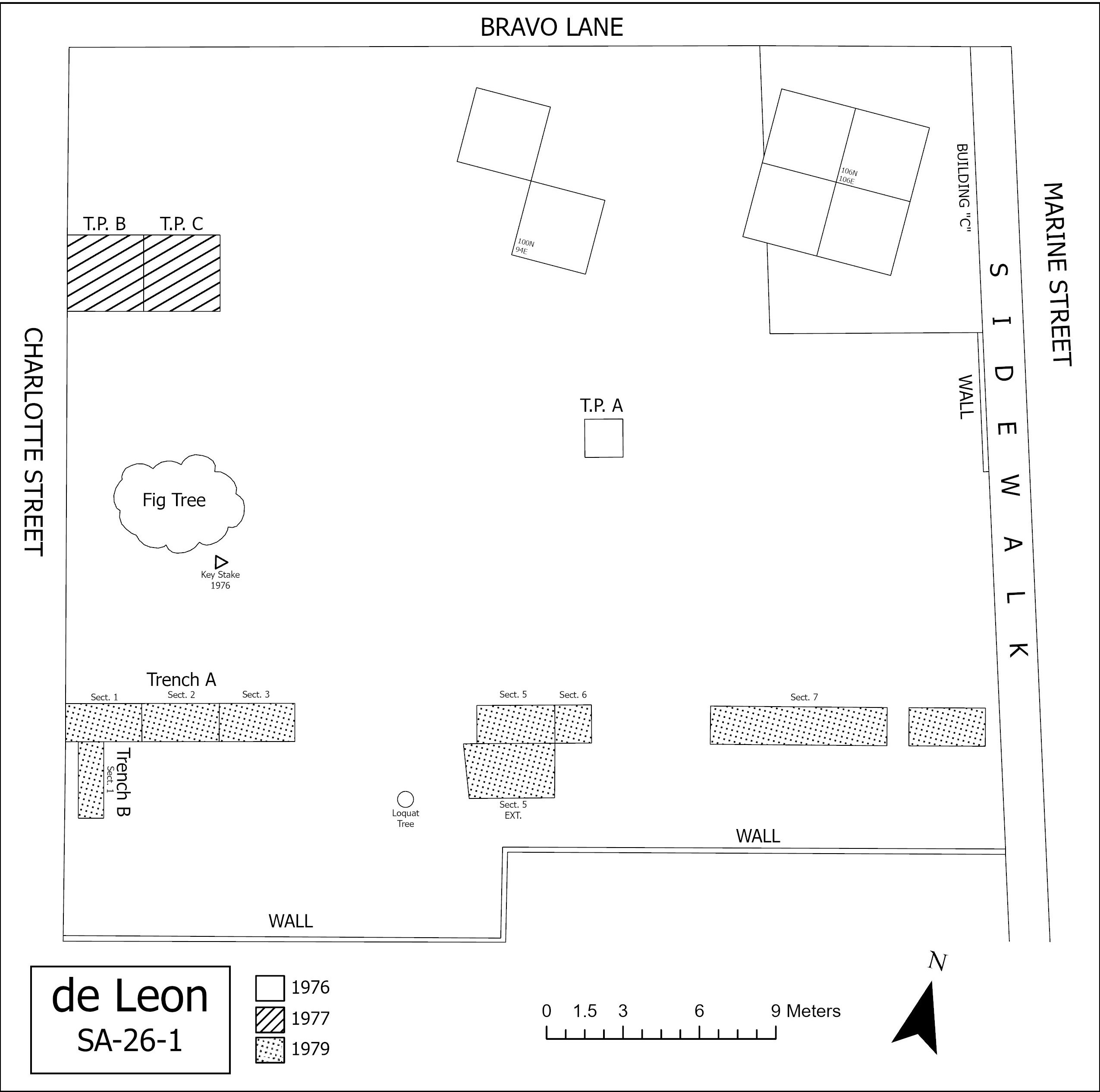
At the time of the 1976 excavation, the de León site was an empty lot. A key stake with the coordinates 100N 100E established the site grid, and a permanent datum plane was set at 3.87 meters above mean sea level. A total of six 3.0 x 3.0 meter units and one 1.5 x 1.5 meter unit (Test Pit A) were excavated. Unit coordinates were based off of their southwest corner, and excavated soil was screened using 1/4 hardware cloth. Test Pit A and the first 3.0 x 3.0 meter unit (106N 106E) were excavated in 15 cm levels to determine the general stratigraphy of the site. Five strata were defined and labeled A through E: A) modern humus; B) coquina and brick rubble associated with the nineteenth and twentieth centuries; C) grey-brown soil, often shell flecked, with eighteenth-century and pre-eighteenth-century proveniences; D) a leached zone with little pre-eighteenth-century material; and E) sterile soil with no cultural material (Singleton 1977).
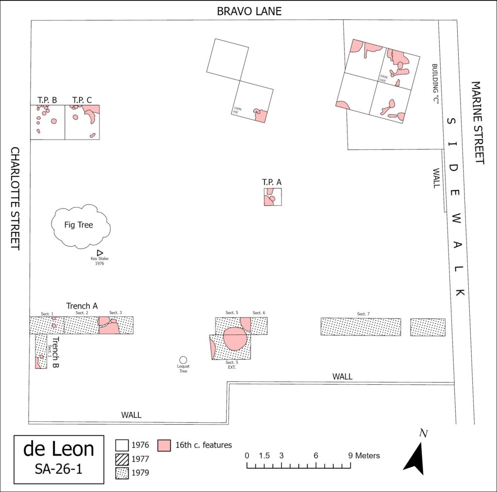
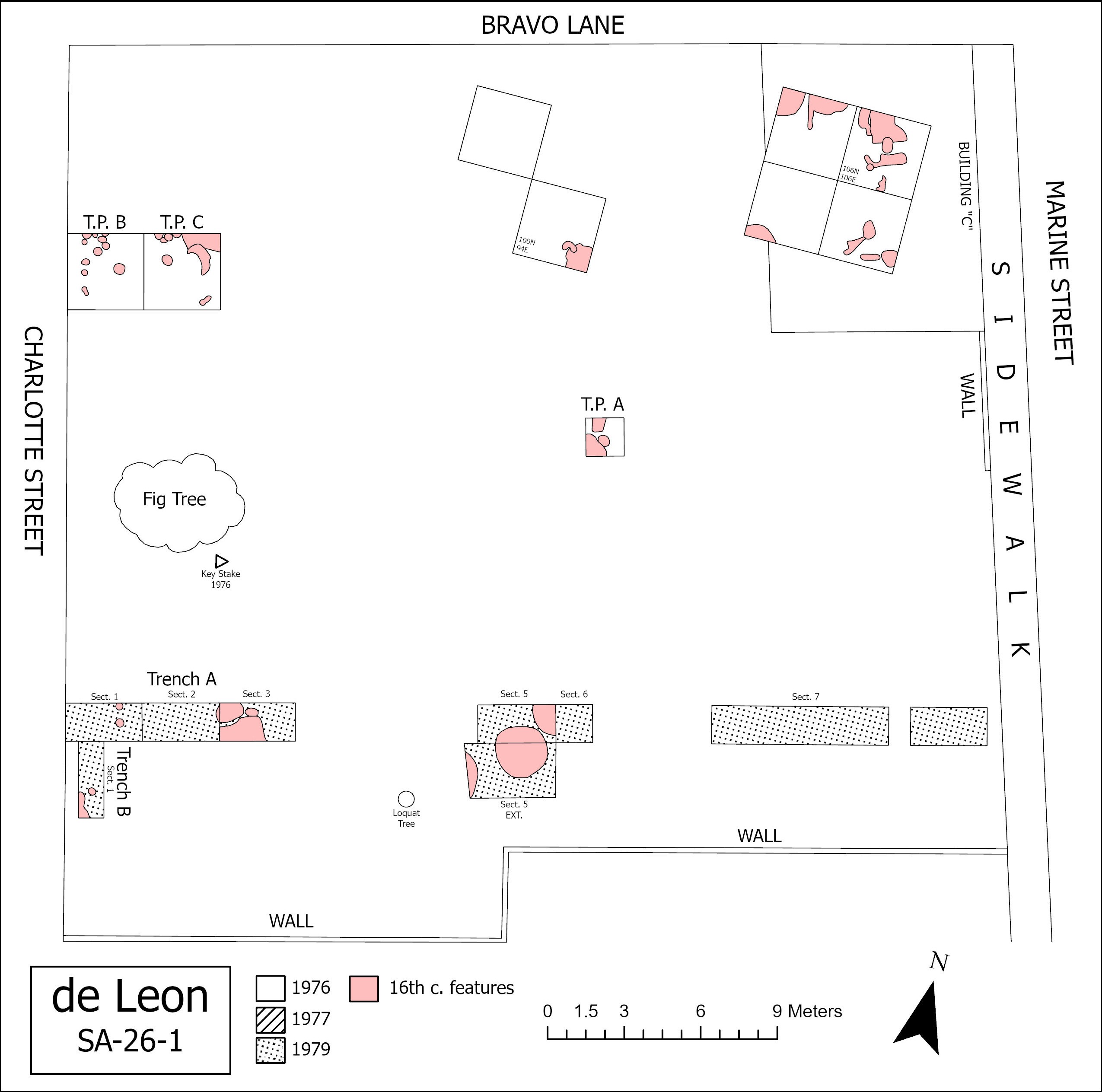
Little evidence of the de León occupation period was uncovered. Singleton (1977) pointed out that the other property de León owned on Block 35, Lot 1 was considerably larger and may have been where he and his family lived during the eighteenth-century. A total of 35 sixteenth- and seventeenth-century features were documented, leading to the conclusion that the site was occupied most heavily during the Spanish I Period. Two of the 35 features consisted of a barrel well and well construction pit while the remainder were identified as refuse pits. The barrel well (Feature 21) was encountered at 2.26 meters below datum, and the well construction pit (Feature 8) bottomed out at 3.22 meters below datum. The barrel well, excavated in 10 cm levels, extended to 4.40 meters below datum and required the use of well points and a pump to fully excavate due to the site’s high water table. In addition to the 35 features dating to the sixteenth and seventeenth centuries, several zone occupational levels were uncovered, bringing a total of 64 proveniences for the 1976 field season.
In 1977, Deagan directed a second excavation with Chad Braley as the field supervisor. The 1976 grid was reestablished, and a datum plane was set at 3.90 meters above sea level. Two 3.0 x 3.0 meter units were placed along the northeast corner of the lot—immediately east of present day Charlotte Street—and excavated material was screened using 1/4 hardware cloth. Unit placement was based on the belief that it was mostly likely the location of a pre-eighteenth-century structure since numerous back lot elements dating to the sixteenth and seventeenth centuries were recorded in the section during a 1976 systematic subsurface auger survey (Deagan 1978a, 1981).
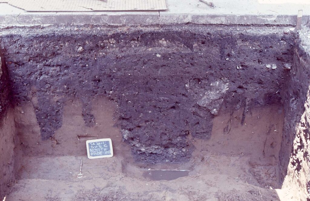
Cultural deposits recovered in the two units varied between 1.0 meter and 1.5 meters in depth. The first unit (Test Pit B) included four midden levels before the matrix was completely obscured. The lowest level of Test Pit B consisted of British pearlwares and creamwares as well as a variety of sixteenth, seventeenth, and eighteenth-century Spanish ceramics. The second unit (Test Pit C) was excavated in six levels and bottomed out at 1.5 meters below datum. Between the two units, 18 features with terminus post quem dates of 1650 or earlier were identified. Additionally, 12 postmolds and two pits were recorded. The postmolds ranged between 10 cm and 18 cm in diameter and appeared to have been driven since there was no evidence of postholes around them. One series of postmolds suggested a fence line, and several clusters were interpreted as a possible structure. Additionally, a cluster in Test Pit C (Postmolds 42, 43, 16, and Pit 8) contained, in addition to sixteenth-century artifacts, a fragment of clay daub that may have been used for wattle and daub construction. Deagan (1978a: 76) remarked that a complete pattern for pre-eighteenth-century components could not be determined due to various deep British Period and Spanish II Period deposits in the northeast corners of both test units.
In 1979, Olga Caballero and Martha Zierden supervised a Florida State University field school with Deagan as the principal investigator. At the time the lot was scheduled for development and the aim of the excavation was to obtain as much archaeological information as possible. Specific attention was given to locating and defining additional sixteenth-century components following the 1976 auger survey and 1977 field season (Deagan 1978a; Braley 1977).
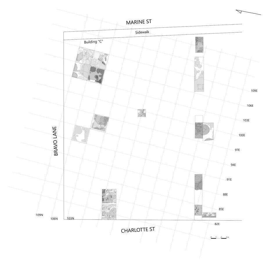
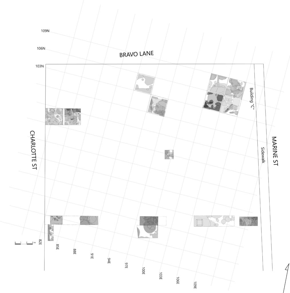
Prior to the excavation, approximately 30 cm of the lot was bulldozed and graded. Furthermore, an additional 10 cm in the sections planned for excavation was shoveled and discarded. Three trenches (labeled A through C) were opened, and based on their location it was determined that portions fell within the properties previously owned by Juan Tomas de Castilla and Dona Barbara Garcia. Trench A included de Castilla’s lot (property #289) and Trench B extended into Garcia’s lot (property #287) (Caballero and Zierden 1979). The 1976 site grid was reestablished, and field protocols from earlier seasons were maintained with a datum plane set at 3.50 meters above sea level. Trench A measured 1.5 x 20.3 meters and was oriented east to west, perpendicular to Charlotte Street and Marine Street. Additionally, Trench A was broken into six sections (Sections 2 and 6 were not excavated, and Section 4 was not assigned or staked out). Section 1 (93N 95E) measured 1.5 x 2.0 meters and was approximately one meter east from the curb on Charlotte Street. Section 3 (93N 100E) measured 1.5 x 3.0 meters. Section 5 (93N 110E) was 1.5 x 3.0 meters and received a 3.0 x 3.7 extension (91.5N 110E) to the south. A backhoe was used to open Section 7 (92.7N 119.1E), which measured 2.0 x 6.8 meters. The purpose of Section 7 was to acquire a profile of the north wall so that a composite profile of the entire site running from east to west could be obtained (Caballero and Zierden 1979: 7). Trench B ran north to south along Charlotte Street and measured 1.5 x 3.0 meters. Trench C (93N 126.8E) was placed to the east of Trench A, Section 7. Available field records do not describe the results of Trench C, but it was most likely excavated to capture the remaining east to west north wall profile of the entire site.
The excavation of Trench A, Section 1, led to the identification of 10 Areas (generally defined as amorphous soil discoloration or an intrusion into the soil matrix but, in this case, included trash pits and unidentified pits). Of the 10 areas, only two (Area 7 and 8) turned out to be of significance. Area 7 comprised of a large deposition of whole oyster shell within a dark brown soil matrix. Just above Area 7, a foundation (Feature 50) composed of four coquina blocks and lime mortar was uncovered, suggesting that Area 7 was perhaps a shell fill layer used to form a solid surface for the foundation. Caballero and Zierden (1979: 10) note that Feature 50 represented a construction style called mamposteria, which involves setting wooden beams into the coquina wall foundations to provide added stability and in-house supports. A rectangular postmold (PM 1) was also identified. Area 8 consisted of grey-brown loose sandy soil with some whole shell that extended underneath Feature 50. The construction date of the foundation was determined to be sometime between the late eighteenth and early nineteenth centuries.
Trench A, Section 3, was excavated in 10 cm levels and determined that the strata dated to the Spanish II Period. Several intrusions were documented below Zone 2, including Area 1 and three large features (Features 51, 54, and 55). Area 1 appeared to be either a large trash pit or fallen chimney based on the recovery of ash, whole bricks, brick fragments, burned plaster and mortar, and melted glass (Caballero and Zierden 1979: 12-13). Nineteenth-century artifacts were located directly below Area 1. Feature 55 was identified as a probable trash pit. Features 51 and 54 made up a well construction pit and barrel well, respectively. The well pit, discovered at 1.64 meters below datum and excavated in 10 cm levels, measured 1.8 meters in diameter. The base of the well pit was not reached due to the collapse of the unit’s baulk while pumping out water. Nevertheless, diagnostic artifacts recovered suggested that it was dug around 1795 and filled after 1820. Also excavated in 10 cm levels, the barrel well (Feature 54) ranged from 1.14 to 0.64 meters in diameter and included heavy shell flecking. The base of the barrel well was not reached due to wall slumping.
The soil matrix in Trench A, Section 5, was completely soaked in either kerosene or some other heating fuel (Caballero and Zierden 1979: 4). Although most of Section 5’s Zone 1 was removed using a front-end loader, a 75 x 75 cm portion was screened and saved. Excavations of Section 5 began at a depth of 1.73 meters below datum and proceeded in 10 cm levels. A large number of intrusions and disturbances were recorded along with 11 areas and several features. Two areas (4 and 10) dated to the nineteenth-century Territorial Period, and four others (Areas 1, 2, 3, and 9) along with a postmold fell within the Spanish II Period. Other discoveries included two features, a trash pit, a well construction pit (Feature 66) that dated to the seventeenth-century, and a number of sixteenth-century components. The sixteenth-century components became a focal point and included a posthole (PH 2), two postmolds (PM 4 and 5), four trash pits (Areas 8, 11, 12, and 13), two well construction pits (Feature 57 and 61), and two barrel wells (Feature 60 and 62). Heavy rains and the site’s high water table prevented the full excavation of Area 13 and Feature 66. An extension of Trench A, Section 5, was necessary to fully excavate Feature 57 and Feature 62. Feature 57, discovered at 1.41 meters below datum, was approximately 2.01 meters in diameter. Feature 62 was excavated in 15 cm levels and had a diameter of 65 cm.
Several areas, features, and postmolds dating between the sixteenth and nineteenth centuries were documented in Trench A, Section 7 (Zierden 1979). Most were thought to have been from the seventeenth-century and include two postmolds (PM 2 and 3) and three areas (2, 3, and 4). A well (Feature 70) constructed of interlocking coquina blocks measuring 95 cm in length was also recorded. Zierden (1979: 9) remarked that the discovery of the coquina well posed problems since a backhoe used to open up Section 7 likely erased the presence of the well in the preceding levels of the unit. The coquina blocks contained no traces of mortar and were perhaps used to support a wooden casing. A number of molded bottles with hand-tooled lips were recovered within the well along with a hard rubber comb, providing a tentative construction date sometime during the mid-to-late nineteenth-century.
Due to time constraints, only the western half of Trench B was excavated. The most significant discovery in Trench B consisted of two wall footings. Originally interpreted as a single wall footing (Feature 56) of highly compacted lime mortar, whole oyster shells, some clam shells, and coquina blocks, the wall footing was later divided into two features (Features 56a and 56b) when it was discovered that 56a intruded into 56b. Feature 56a, located approximately 1.85 meters below datum, was 44 cm thick and bottomed out onto Area 19. Feature 56b was similar in composition to 56a but less compact with a lower percentage of oyster shell.
Summary of Research and Analysis
The de León site has provided abundant evidence of domestic occupation from the mid-sixteenth-century to the nineteenth-century. Excavations conducted in 1976 and 1977 determined that the site was occupied most heavily in the first half of the seventeenth-century during the colonial period (Deagan 1977), and the results of the 1979 excavation expanded on prior field seasons in an attempt to further locate and define sixteenth-century components. A number of wells and well construction pits were identified, and a possible structure dating to the late sixteenth or early-seventeenth century was documented. Several ceramic varieties not encountered on other colonial St. Augustine house lots, such as Feldspar Inlaid, burnished redware, and Mesoamerican colonial wares, were recovered as well (Deagan 1978b: 36; Singleton 1977: 144-150).
Zooarchaeological analyses by Reitz and Scarry (1985) concluded that SA 26-1 had the highest diversity of animal species when compared against several other colonial St. Augustine house lots. Pig (Sus scrofa) was the major domestic species identified in the 1976 and 1977 assemblage while the 1979 assemblage—directly south of the 1976 and 1977 excavations—exhibited a preference for domestic cattle (Bos taurus) and gopher tortoises (Reitz and Scarry 1985: 89).
Gifford Waters and Charles Cobb
Florida Museum of Natural History
University of Florida, Gainesville, FL
July 2025
Field Methods and Protocols: Unless otherwise noted for all seasons currently uploaded to DAACS:
- The metric system.
- Water screened using ¼ mesh.
- Unit coordinates are based on the southwest corner.
Datum: The key stake (datum) for the 1976 excavations was given the unit coordinates 100N 100E. However, the grid coordinates for successive excavations (1977 and 1979) do not correlate with the 1976 grid. There are no unit coordinates for the 1977 field season. Rather, all units were labeled test pits. However, the unit coordinates for the 1979 excavations were added to the 1976 maps, effectively tying into the 1976 site grid.[1]
Field Methods and Protocols:
1976: Key stake put in designated 100N 100E at the southwest corner of the Marrion Motor Lodge, north building. Initial test pit (Test Pit A) taken down in arbitrary (15cm) levels to determine the natural stratigraphy. Following Test Pit A, all units were provided unit coordinates.
1977: The de Leon Field notebook (1976, pg. 154) for April 8, 1977, states: “We have given up trying to tie in the [1976] key stake at this point. We are gridding off the cleared area in the concrete patio – two units, due to the irregular area of concrete taken up” will “throw off our squares with last year’s work.”[2] The aim of the field season was carrying forward with the 1976 work with an emphasis on testing the back of the lot under concrete for structural remains. The new site datum is 3 cm below the 1976 datum. Excavations began in arbitrary 15 cm intervals.
1979: No field protocols are laid out in the two 1979 field notebooks.
Unit Measurements: The following unit sizes for the field seasons currently uploaded to DAACS.
- 1976: 3.0 x 3.0 meter
- 1977: 3.0 x 2.7 meter
- 1979: 2.0 x 1.5 meter, 3.0 x 1.5 meter, 6.8 x 2.0 meter
[1] These are apparent with an addition of unit number next to the 1976 unit coordinates.
[2] Note: the 1977 season field notes begin in the 1976 field notebook (pg. 154).
| Feature | Feature Type | Unit Corner |
| F1 | Unidentified | Test Pit A |
| F2 | Rubble scatter | 106N 106E, 103N 106E, 106N 103E |
| F3 | Unidentified | 106N 106E |
| F4 | Wall, interior stone | 106N 106E |
| F5 | Wall, interior stone | 106N 103E |
| F6 | Unidentified | 106N 106E |
| F7 | Unidentified | 106N 103E |
| F8 | Pit | 106N 103E, 103N 103E |
| F9 | Pit, trash | 103N 106E |
| F10 | Pit, trash | 106N 103E |
| F11 | Foundation stone | 103N 91E |
| F12 | Pit | 103N 91E |
| F13 | Pit, trash | 106N 103E |
| F14 | Pit | 103N 106E |
| F15 | Pit | 103N 91E |
| F18 | Unidentified | 100N 94E |
| F19 | Trench, unidentified | 100N 94E |
| F20 | Trench, unidentified | 103N 106E |
| F21 | Well | 103N 103E |
| F22 | Pit | 103N 103E |
| F23 | Unidentified | 103N 103E |
| F24 | Pit | 100N 94E |
| F25 | Pit | 100N 94E |
| F27 | Pit | Test Pit B |
| F28 | Unidentified | Test Pit B |
| F30 | Unidentified | Test Pit B |
| F31 | Pit | Test Pit B |
| F32 | Unidentified | Test Pit B |
| F34 | Unidentified | Test Pit C |
| F36 | Rubble scatter | Test Pit C |
| F38 | Pit | Test Pit C |
| F40 | Unidentified | Test Pit C |
| F43 | Unidentified | Test Pit C |
| F44 | Unidentified | Test Pit C |
| F47 | Unidentified | Test Pit C |
| F48 | Midden, shell | Test Pit C |
| F49 | Rubble scatter | Test Pit C |
| F50 | Unidentified | Test Pit C |
| F51 | Pit | 93N 100E |
| F54 | Barrel well | 93N 100E |
| F55 | Pit | 93N 100E |
| F56b | Wall, interior stone | 90N 95E |
| F57 | Pit, barrel well | 91.5N 110E, 93N 110E |
| F60 | Barrel well | 91.5N 110E, 93N 110E |
| F61 | Barrel well-like | 93N 110E |
| F62 | Barrel well | 91.5N 110E |
| F63 | Pit | 91.5N 110E |
| F64 | Pit, trash | 91.5N 110E |
| F65 | Pit, trash | 91.5N 110E |
| F66 | Barrel well | 91.5N 110E |
| F67 | Pit | 93N 126.8E |
| F68 | Pit | 92.7N 119.1E |
| F70 | Coquina well | 92.7N 119.1E |
| F71 | Coquina well | 92.7N 119.1E |
| PH1A | Posthole | 93N 100E |
| PH1B | Posthole | 93N 110E |
| PH7 | Posthole | Test Pit B |
| PH15 | Posthole | Test Pit B |
| PH16 | Posthole | Test Pit B |
| PH21 | Posthole | Test Pit B |
| PH41 | Posthole | Test Pit B |
| PH43 | Posthole | Test Pit C |
| PHC | Posthole | 103N 106E |
| PHD | Posthole | 103N 103E |
| PHE1 | Posthole | 106N 103E |
| PHE2 | Posthole | 103N 103E |
| PHP | Posthole | 103N 103E |
| PHQ | Posthole | 103N 103E |
| PHR | Posthole | 103N 103E |
| PIT1A | Pit | Test Pit B |
| PIT1B | Pit | 93N 126.8E |
| PIT5 | Pit | Test Pit B |
| PIT7 | Pit | Test Pit C |
| PIT9 | Pit | Test Pit C |
| PITA | Pit | 103N 91E |
| PITB1 | Pit | 106N 106E |
| PITB2 | Pit | 103N 91E |
| PITC | Pit | 103N 91E |
| PITE1 | Pit | Test Pit A |
| PITE2 | Pit | 103N 91E |
| PITF1 | Pit | 106N 106E |
| PITF2 | Pit | 103N 106E |
| PITF3 | Pit | 103N 103E |
| PITH | Pit | 106N 106E |
| PITJ | Pit | 106N 106E |
| PITL | Pit | 103N 103E |
| PITM1 | Pit | 106N 106E |
| PITM2 | Pit | 103N 103E |
| PITN | Pit | 106N 106E |
| PITP1 | Pit | 106N 106E |
| PITP2 | Pit | 103N 103E |
| PITQ | Pit | Test Pit A |
| PITT | Pit | Test Pit A |
| PITU | Pit | 103N 103E |
| PM1A | Postmold | 93N 110E |
| PM1B | Postmold | 93N 126.8E |
| PM2A | Postmold | 92.7N 119.1E |
| PM2B | Postmold | 93N 126.8E |
| PM3A | Postmold | 93N 95E |
| PM3B | Postmold | 93N 126.8E |
| PM4 | Postmold | 93N 110E |
| PM5 | Postmold | 90N 95E |
| PM8 | Postmold | 93N 126.8E |
| PM9 | Postmold | 90N 95E |
| PM10 | Postmold | 90N 95E |
| PPHC | Possible posthole | Test Pit A |
| PPHD | Possible posthole | Test Pit A |
| PPHB | Possible posthole | 106N 103E |
| PPHT | Possible posthole | 106N 103E |
| PPH2 | Possible posthole | 93N 110E |
| PPM2 | Possible postmold | 93N 110E |
| PPM3 | Possible postmold | 93N 110E |

In contrast to most archaeology websites, iDigStAug contains all of the primary documents associated with the field investigations. By “primary documents” we mean literally all of the field records, field maps, catalogue forms, analytical forms, and photographic slides. In addition, we include technical reports, M.A. theses, and Ph.D. dissertations summarizing some of the studies conducted on these sites. Although iDigStAug contains a digital inventory of re-analyzed artifacts and related contextual records, the availability of the primary documents allows individuals to reach down into minute detail to examine data or drawings that may be of interest. The files are saved in a PDF/A format, an archival protocol that ensures long-term accessibility.
